Another County Older Than the State of Alabama–Baldwin County , land of the #5 Alabama license plates!http://www.baldwineda.com/Quality_of_Life/museums_attractions.htm
http://www.archives.state.al.us/counties/baldwin.html
http://alabamamaps.ua.edu/historicalmaps/counties/baldwin.html

http://www.perdidovineyards.com/

http://www.bluegillrestaurant.com/
The Bluegill Restaurant on the Causeway in Spanish Fort was probably the greatest place in Baldwin County to hear live music before Katrina. They hope to reopen soon. Their sister restaurant, The Beach House Grill http://www.thebeachhousegrill.com/websites/BeachhouseGrill/BeachhouseGrill/, is also located on the Causeway up the hill so it has taken over as the main music venue since the devastation of the Bluegill by the hurricane on August 29.

http://www.florabama.com/index.htm The legendary FLORA-BAMA is located in Escambia County, Florida at the Alabama-Florida line on the Baldwin County portion of Perdido Key. The bar has reopened since IVAN & rebuilding has begun!
BALDWIN COUNTY HISTORY
Third oldest county in Alabama. Created in 1809 while still part of Mississippi Territory. Named for Abraham Baldwin (1754-1807), founder of the University of Georgia, delegate to the Constitutional Convention, member of Congress, 1789-1807. This county once lay west of the Tombigbee River; but, after series of boundary changes, it now lies east of the Mobile and Alabama Rivers. County seat at Bay Minette since 1901; earlier seats at McIntosh Bluff, Blakely, and Daphne. It has long been a center of conflicting claims: by Spain, France, and England; by royal governors of Florida, Louisiana, Carolina, Georgia, and West Florida until the Mississippi Territory formed in 1798 and from it, the Alabama Territory in 1817. In struggle for control of the Southeast, many armies have camped in this area:
1528–Narvaez, Spanish conquistador http://www.enchantedlearning.com/explorers/page/n/narvaez.shtml
1588–DeLuna, Spanish colonizer
http://www.tsha.utexas.edu/handbook/online/articles/LL/fluff_print.html
1719–Bienville, French colonizer
http://www.biographi.ca/EN/ShowBio.asp?BioId=35608
1780–Galvez, Spanish conqueror
http://www.tsha.utexas.edu/handbook/online/articles/GG/fga10.html
1813–Red Eagle, Indian revolter
http://www.findarticles.com/p/articles/mi_qa4113/is_200410/ai_n9464310
1814–Jackson, American defender
http://www.isidore-of-seville.com/jackson/7.html
1815–Packenham, British invader
http://www.galafilm.com/1812/e/people/pakenham.html
1864–Maury, Confederate defender
http://home.earthlink.net/~southernshamrock/mobile.html
1865–Canby, Federal invader.
http://www.multied.com/Bio/UGENS/USACanby.html

Here's a great description of birdwatching sites in Baldwin County:http://www.alabamacoastalbirdingtrail.com/trails/eastern_shore_loop.asp
This site for the Magnolia Springs Bed & Breakfast introduces you to the extraordinary Magnolia River/Weeks Bay area, home of the only all-water mail route in the U.S., with daily delivery by boat http://www.magnoliasprings.com/
The Mound Line (Ellicott Line) Historic Marker
http://stockton.civic.club.home.att.net/
[this marker is located in the town of Stockton in North Baldwin County. The text to the marker was written by my close friend, Greg Spies of Coden. The marker was erected during the U.S. Southern Boundary Bicentennial in April of 1999]
Mile Mound #216 located 1200 feet East
Surveyed in 1799 to mark the 31° North Latitude, this line charted the first southern boundary of the United States, separating the U.S. from Spanish Florida. The line was marked at one-mile intervals by earthen mounds approximately fifteen-feet square and three-feet high with a charred lighter-pine post at the center, hence the name Mound Line. Jointly surveyed by Major Andrew Ellicott, U.S. Commissionerhttp://www.lewis-clark.org/content/content-article.asp?ArticleID=2338
, and Esteban Minor, Spanish Commissioner, to determine boundaries as agreed in the Treaty of San Lorenzo in 1795. The line began at the Mississippi River, ran east along 31° North Latitude to the Chattahoochee River, thence eventually to the Atlantic Ocean. Stockton was divided by this line, with some residents living in the United States and some in Spanish Florida. Although Stockton became a "border town," U.S. law generally prevailed in the area.
Confederate Rest Cemetery Historic MarkerThe Grand Hotel [damaged by Katrina but will reopen around the first of the year. The cemetery is located on the grounds of The Grand Hotelhttp://www.marriottgrand.com/hotel_info/hotel_info.cfm
built in 1847] and the Gunnison House served as a hospital for wounded Confederate soldiers from the Battle of Vicksberg during the Civil War. The Confederate Rest Cemetery commemorates more than 300 Confederate soldiers who died while in the hospital. The original tract of seven acres included markers erected to the Unknown Confederate Dead. The records of the soldiers were kept in the hotel until a fire in 1869, when the identities of those buried in Confederate Rest were lost.
Ellicott's Stone Historic Marker
[this marker is actually now located in Mobile County but I suppose the Alabama State Department of Archives & History included it in Baldwin since Baldwin was originally located west of the Tombigbee. On April 9, 1999, I was priviledged to be one of a group of dignitaries who participated in the groundbreaking for this park and the dedication of this historic marker.Earlier that same year, I was chosen to take the stage at Auburn University & receive the plaque which placed ELLICOTT'S STONE in the State of Alabama Engineering Hall of Fame.]

http://www.aspls.org/history/index.html
Erected April 9th, 1799 Marks 1st Southern Boundary of the United States and the Mississippi Territory created in 1798 900 feet East
Stone marked 31° North Latitude separating the U.S. & Spanish Florida. This line of demarcation ran from the Mississippi east, along the 31° parallel to the Chattahoochee River, thence down that river to the mouth of the Flint River, thence on a line to the headwaters of the St. Mary's River, thence down that river to the Atlantic Ocean. Major Andrew Ellicott, appointed by George Washington as U.S. Commissioner to survey the boundary as defined in the Treaty of San Lorenzo (1795), was engaged in this expedition from 1796-1800. Esteban Minor was appointed Commissioner on the Spanish side. In 1803, the Ellicott Stone was selected as the Initial Point to begin the U.S. Public Land Surveys which control land boundaries in southern Alabama & Mississippi (St. Stephens Meridian).
Fort Bowyer Historic MarkerBuilt during War of 1812.
1803 United States claimed Mobile and the bay as part of Louisiana Purchase.
1813 On order of President Madison, this point seized from Spain by U.S. Regulars under Gen. James Wilkinsonhttp://www.tsha.utexas.edu/handbook/online/articles/WW/fwi87_print.html
and militia under Col. John Bowyer. This act extended Mississippi Territory to Bay area. Fort Bowyer, a wooden fort, was built here.
1814 British with Indian allies attacked Fort by land and sea. After three days of fierce assault, the British ship Hermes was sunk; the enemy withdrew to friendly Spanish port of Pensacola.
1815 After Battle of New Orleans, British under Gen. Pakenham attacked here with 500 men from land and 38 war ships. Maj. Lawrence, U.S.A. surrendered with 360 men on the third day. Since peace treaty had already been signed, British retained Fort Bowyer only a few weeks. Americans again occupied the Fort.
1819 work begun on construction of brick fort.
1822 Fort greatly strengthened as urged by President James Monroe. Later renamed Fort Morgan.
Fort Morgan Historic Marker
1833 This fort replaced Fort Bowyer. Built on the star-shaped design of Michelangelo, it is one of the finest examples of military architecture in the New World.

http://www.cr.nps.gov/nr/twhp/wwwlps/lessons/73morgan/73morgan.htm
1861 Seized by Alabama troops on order of Governor Moore.
1861-1864 Strengthened and garrisoned by Confederates guarding the pass against Federal blockading fleet. Guns of fort protected blockade-runners in and out of Mobile Bay.
1864 Admiral Farragut, U.S.N., forcing passage into bay, landed 3000 men. After heavy bombardment by Federal fleet, the interior of Fort lay in smoldering ruins. The garrison surrendered next afternoon.
1865 General Canby U.S.A. landed nearby with 32,500 troops and supplies. He moved up east shore of bay to join 13,200 men from Pensacola and laid siege to defenses of Mobile.
1898 During War with Spain the Fort was strengthened and modernized.
1946 Congress deeded the Fort and 400 acres to Alabama for use as State Park.
Fort Mims Massacre Historic Marker http://home.att.net/~fortmims/
Here in the Creek Indian War (1813-14) took place the most brutal massacre in American history. Indians took the fort with heavy losses, and then killed all but about 36 of some 550 in the fort. The Creeks had been armed by British at Pensacola in this phase of War of 1812.
Kennedy Mill, C. 1811 Historic Marker
Site of one of Alabama's first sawmills.
In 1811, Joshua Kennedy engaged Jesse Ember to build two water-powered sawmills, convertible to grist mills, for a total of $1400. The mills were operated by Kennedy through 1820; were burned twice, once by Indians. The mill dam and site were later used by the Bryne Brothers, and then by Hastic & Silver Co. until 1906, when they were abandoned.
Noble Leslie DeVotie Historic MarkerFirst Alabama soldier to die in the Civil War. Drowned February 12, 1861, while on duty as chaplain of the Alabama troops here. Before enlisting, he was the pastor of Selma Baptist Church. He was 23 at time of death. Noble Leslie DeVotie–First Alabama soldier to lose life in Civil War. DeVotie graduated in 1856 from University of Alabama; Presbyterian Theological Seminary at Princeton in 1859. In 1856 at the University of Alabama, he was chief founder of Sigma Alpha Epsilon Fraternity, the only national social fraternity founded in the Deep South. (Located at Fort Morgan)
School of Organic Education Historic Marker
On this site, a significant educational experiment was launched by Marietta Johnson, who founded the School of Organic Education in 1907. Believing that children should be motivated by natural free development rather than by competition, she did away with examinations and concentrated on the growth of the whole person. In 1909, the Single Tax Corporation provided this 10-acre plot. John Dewey, whose progressive education principles were shared by Johnson, visited the school in 1913. The school reached its zenith during the 1920's. The City of Fairhope acquired the campus in 1987 and leased it to Faulkner State Junior College. Listed on the National Register of Historic Places in 1988.

http://www.siteone.com/tourist/blakeley/
The Battle of Fort Blakely, the last major battle of the Civil War. 55,000 troops participated in this campaign to capture Mobile. This site is considered by experts today to be the best preserved Civil War battlefield.

http://www.asama.org/visitor/index.asp
This museum in Daphne is believed to house the largest collection of sport art in North America.

http://www.mosaic-tile-design.com/malbis-plantation-alabama.html
The interior of Malbis Greek Orthodox Church, one of the most impressive sanctuaries you will ever see. This experience will stick with you.
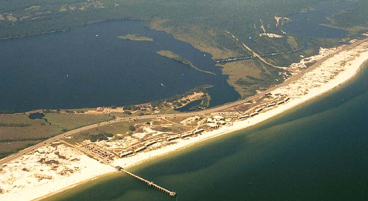
http://cb4go.com/State%20Park/StateParksAlGulfStParkGulfShoresGulfStateParkOvAll.htm
6000 acres of Paradise located on the shores of the Gulf of Mexico: GULF STATE PARK!
Some interesting Baldwin County place names:
Battles Wharf, Bay John, Bon Secour, Darling Landing, Dixie Landing, D'Olive, Fobbs Ferry, Fort Mims, Gopher Hill, Minnie, Narcissus, Navy Cove, Old Island Landing, Palmetto Beach, Paradise, Perdido Beach, Pilot Town, Pinchona, Redtown, Roscoe, Sea Cliff, Seminole, Shell Banks, Soldier Creek, Steam Mill Landing, Styx, Sumatra, Tensaw Station, Whitehouse Forks, Wilkens Bend Landing, Yupon
posted by robertoreg at 2:41 PM
![]()

0 Comments:
Post a Comment
<< Home